Komplexe Daten in klare Entscheidungen verwandeln.
Moderne Spatial-Asset-Management-Lösungen für führende Unternehmen
Software-Demo anfordern
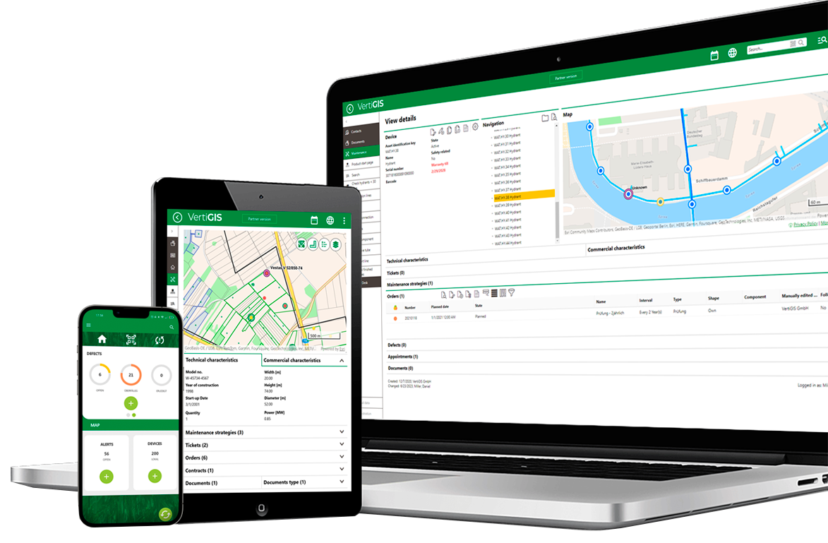
VertiGIS Neo bietet webbasierte, KI-gestützte Lösungen der nächsten Generation – entwickelt für die Anforderungen großer Organisationen. Ob in der Cloud, On-Premises oder hybrid: VertiGIS Neo verbindet Daten, Menschen und Prozesse über den gesamten Asset-Lebenszyklus hinweg.
Wie VertiGIS Neo Kunden messbaren ROI erzielen

100.000 Stunden Rechercheaufwand eingespart – durch effizienteres Case Management

10 Mio. Euro jährliche Einsparungen – durch optimierte Workflows und die Vermeidung doppelter Arbeit

2 Mio. Euro jährliche Einsparungen – durch bessere Dokumentation und Nachverfolgung von Netz-Assets über kommunale Grenzen hinweg
Die cloudorientierte Zukunft branchenspezifischer Geoinformationslösungen
Organisationen, die komplexe Netze betreiben – etwa Versorgungsunternehmen, Telekommunikationsanbieter, Kommunen oder Infrastrukturbetreiber – brauchen mehr als digitale Karten. Sie benötigen eine Plattform, die Daten, Teams und Prozesse über den gesamten Asset-Lebenszyklus hinweg intelligent miteinander verbindet. VertiGIS Neo kombiniert Cloud-Hosting, native mobile Anwendungen, KI-gestützte Workflows und branchenspezifische Funktionen. So entstehen intelligentere, schnellere und resilientere Abläufe – im Büro ebenso wie im Außendienst.
Fortschrittliche Lösungen für tägliche Herausforderungen

Integrierte Business-Systeme ermöglichen Ihrem Team die Echtzeit-Verfolgung von Assets und schaffen die Grundlage für vorausschauendes Management. Saubere, vernetzte Daten verbessern Entscheidungen, machen Zusammenhänge zwischen bislang getrennten Datenquellen sichtbar und fördern die Zusammenarbeit. Gleichzeitig entsteht eine belastbare Datenbasis für den gezielten Einsatz von KI.

VertiGIS Neo unterstützt eine effizientere Netzplanung durch den gezielten Einsatz räumlicher Daten. Infrastrukturstandorte lassen sich besser bewerten, Nachfrageentwicklungen prognostizieren und Lasten optimal verteilen. Durch die Analyse von Gelände, Demografie und Nutzungsmustern können Unternehmen Ausbauprojekte fundierter planen, die Versorgungssicherheit erhöhen und Nachhaltigkeitsziele besser erreichen.

Mit VertiGIS Neo optimieren Unternehmen ihre Außendienstprozesse – von der Echtzeit-Überwachung von Flotten über die Priorisierung von Aufgaben bis hin zur präzisen Aktualisierung von Asset-Daten direkt vor Ort. Das Ergebnis: mehr Effizienz, weniger Ausfallzeiten und geringere Kosten bei gleichzeitig zuverlässigerem Service.

Moderne Unternehmen nutzen Geoinformationstechnologie, um Assets in Echtzeit zu visualisieren, Schäden schneller zu bewerten und Services nach Stürmen, Waldbränden oder anderen Ereignissen effizient wiederherzustellen. VertiGIS Neo verbessert die Abstimmung zwischen Teams, vereinfacht Reporting und Compliance und unterstützt eine präzisere Budgetplanung – bei gleichzeitig reduzierten Ausfallzeiten und Kosten.

Unternehmen stehen zunehmend vor der Aufgabe, Umweltauflagen einzuhalten, nachhaltiger zu wirtschaften und zusätzliche regulatorische Anforderungen zu erfüllen. VertiGIS Neo bietet Werkzeuge, um Auswirkungen zu überwachen, Compliance-Prozesse zu unterstützen und den Betrieb langfristig nachhaltiger zu gestalten.

VertiGIS Neo verändert die Art und Weise, wie Unternehmen mit ihren Kunden interagieren. Echtzeit-Störungskarten und Portale zur Verbrauchsüberwachung informieren Kunden transparent und unterstützen eine effizientere Ressourcennutzung. GIS-integrierte CRM-Prozesse beschleunigen Serviceanfragen, verkürzen Reaktionszeiten und steigern die Kundenzufriedenheit.
Ihre GIS-Lösung in der Cloud. Ihre Branche. Ihre Zukunft.
VertiGIS Neo:
Lösungen mit klarer Mission
Wie die VertiGIS Neo-Lösungen weltweit Wirkung entfalten


Persönliche Beratung & Demos
Demo-Projekte jetzt live testen
Unsere Expert*innen helfen bei der Lösung Ihrer branchenspezifischen Herausforderungen.
Lassen Sie uns wissen, wer Sie sind, und wir werden Sie in Kürze kontaktieren!
FAQs – Are VertiGIS Neo Solutions right for your organization?
| What is VertiGIS Neo and what does it do? | VertiGIS Neo is our modern portfolio of cloud-first, AI-enabled geospatial solutions that help utilities, telecommunications providers, local governments, and enterprise organizations manage their spatial assets across the entire network lifecycle. It unifies flexible deployment options like cloud hosting, mobile integration, AI-enabled functions, and industry-informed workflows into a single, modern platform. VertiGIS Neo contains VertiGIS Networks, VertiGIS Studio, VertiGIS FM, and VertiGIS ConnectMaster. Each solution addresses specific, real-world industry challenges — from network planning and field data capture to outage management and regulatory compliance reporting. |
| How does VertiGIS Neo integrate with Esri's ArcGIS platform? | VertiGIS Neo is purpose-built to extend and maximize the value of your Esri ArcGIS investment. Rather than replacing ArcGIS, VertiGIS Neo solutions sit on top of the ArcGIS infrastructure — including ArcGIS Utility Network — to deliver targeted, industry-specific workflows that generic Esri tools alone do not address. This means organizations benefit from: VertiGIS Networks, which puts ArcGIS Utility Network into operational action for water, gas, electric, and telco providers VertiGIS Studio, which extends ArcGIS with low-code/no-code web and mobile application development VertiGIS holds Esri Platinum Partner status and has earned Esri specialty designations in Network Management, ArcGIS Cloud Services, and State and Local Government, reflecting a deep, validated partnership. |
| How does VertiGIS Neo use AI to improve geospatial operations? | VertiGIS Neo embeds AI capabilities across three dimensions: end-user productivity assistants, app-builder co-pilots, and enterprise-level process transformation tools. Rather than treating AI as a separate add-on, Neo delivers AI functionality directly within everyday workflows across web, mobile, and desktop interfaces. Current AI capabilities embedded in Neo solutions include: AI Assistants: Natural language chat interfaces that allow users to issue queries, generate print outputs, and receive contextual guidance without GIS expertise Image Recognition: Automatically identifies asset type and condition from field photos, eliminating manual data entry Workflow Automation: Processes documents such as invoices and auto-populates structured data fields |
| What cloud deployment options does VertiGIS Neo support? | VertiGIS Neo supports three distinct deployment models — Managed Cloud (SaaS), Private Cloud, and Hybrid — giving organizations the flexibility to meet their data sovereignty, security, and infrastructure requirements without compromise. Neo Managed Cloud (SaaS): VertiGIS manages the complete data, GIS infrastructure, and solution stack. Includes proactive monitoring, ISO 27001 and GDPR-compliant security, and predictable subscription pricing that reduces capital expenditure Neo Private Cloud: Solutions are deployed on verified, right-sized architecture behind your organization's firewall. Turn-key deployment and remote maintenance minimize installation and upgrade costs while keeping all data within your network Neo Hybrid: VertiGIS SaaS solutions operate in the cloud while your GIS infrastructure and data remain on-premises — keeping you current on the latest solution technology without relinquishing data control For organizations with strict data security policies — particularly in regulated sectors like utilities and government — the Private Cloud and Hybrid options are purpose-designed to accommodate compliance requirements without sacrificing access to modern capabilities. |
| Why should utilities choose VertiGIS Neo for Esri Utility Network migration? | VertiGIS is one of Esri’s biggest global partners and offers applications uniquely built for the Esri Utility Network (UN), at a time when 87% of utilities plan to migrate by 2030 and the Geometric Network end-of-life deadline is set for 2028. VertiGIS provides the industry expertise and ready-built application layer needed to make UN migrations operationally valuable from day one. Three reasons utilities choose VertiGIS Neo for their UN migration: Pre-built domain packages: Water, gas, electric, telco, sewer, and district heating domain packages eliminate the need to build industry data models from scratch, significantly reducing migration timelines and custom development costs Out-of-the-box workflows for non-GIS users: VertiGIS Networks delivers controlled, workflow-based editing experiences designed for field technicians and operational staff — not just GIS professionals — extending the value of UN investment to a much wider user base Proven ROI at scale: VertiGIS customers have documented millions of dollars in cumulative savings from streamlined workflows, reduced staff research time, and the elimination of duplicated work — outcomes directly tied to a well-executed UN implementation. |
| Does VertiGIS Neo work for organizations that are not ready to move to the cloud? | Yes. While VertiGIS Neo is cloud-first by design, the platform explicitly supports on-premises and hybrid deployments for organizations with strict data governance, regulatory, or cybersecurity requirements. Cloud adoption is presented as an option — not a prerequisite — for benefiting from Neo solutions. VertiGIS recognizes that many utilities and telecom providers operate under data sovereignty regulations or internal security policies that restrict public cloud use. For these organizations we offer on-premises configurations. You still benefit from VertiGIS' low-code web tools, native mobile applications, ERP integrations, and AI-enabled workflows — the full Neo capability set, without requiring cloud migration. You choose which deployment fits your needs, and if things change in the future, VertiGIS is here to help you scale and adapt. |
| Why is geospatial data quality crucial for your organization? | Geospatial data provides the fundamental "where" for your information, offering critical spatial context that uncovers complex patterns, trends, and relationships. For modern enterprise applications and advanced AI/ML models, it's crucial that this data is clean, accurate, and synced across business systems in your organization. At its core, geospatial data allows for the sophisticated visualization of assets, infrastructure, and events on a dynamic map interface. This is far more than simple pin-pointing; it enables complex spatial analysis, such as optimizing multi-stop logistics routes by factoring in real-time traffic and road network constraints, or performing site suitability analysis for new infrastructure by layering demographic, environmental, and topological data. For AI and machine learning, integrating geospatial data enriches algorithms and elevates their predictive power. By understanding the spatial distribution and relevant attribution of asset data, models can achieve far greater accuracy in tasks like predictive maintenance, risk assessment, and environmental monitoring. By leveraging world-leading data quality and data governance capabilities, we ensure that the foundational data powering these systems is accurate, consistent, and reliable. This allows both your AI tools and our applications to deliver smarter, spatially-aware solutions that you can trust. |