How a user-friendly web GIS unlocked the full value of Esri Utility Network
Executive Summary
Hunter Water modernized access to its utility network data by transitioning from Esri’s legacy Geometric Network to the Utility Network Model and implementing VertiGIS Networks with support from Woolpert. While the new data model delivered advanced network capabilities, VertiGIS Networks provided the intuitive, web‑based interface business users needed to visualize, trace, and query complex infrastructure without GIS expertise. The result is a more efficient and accessible GIS environment that streamlines workflows, improves customer service, and provides a scalable foundation to support Hunter Water’s ongoing operational and technology needs.
Introduction
Located two hours north of Sydney, Hunter Water is one of Australia’s largest water utilities, providing drinking water, wastewater, recycled water, and stormwater services to over 600,000 residents and businesses across the Lower Hunter region in New South Wales.
The Challenge
At Hunter Water, GIS is an integral system used to map, manage, and analyse water infrastructure for effective operations, maintenance, and planning. For the past decade, Hunter Water managed its GIS data using the Geometric Network model, a basic framework that represents and analyses utility network connectivity and flow through simple feature-based relationships.
However, Esri’s Utility Network Data Model (UNM) introduced a more advanced, modern system for modelling complex utility networks. The Utility Network offers enhanced capabilities, such as real-world connectivity, dynamic tracing, rule-based validation, scalability, and full support for modern web and mobile workflows. As part of its GIS Transformation Project, Hunter Water transitioned from the Geometric Network to Esri’s Utility Network Model, now considered an industry standard for utilities.
Despite the new model’s robust and powerful capabilities, business users needed a user-friendly interface to access and query the data they required. Hunter Water sought a reliable off-the-shelf solution to meet their operational needs, including a configurable web mapping solution that could facilitate utility network tracing and offer advanced query tools.
The Solution
To address this challenge, Hunter Water partnered with Woolpert, the Australian distributor and implementation partner of VertiGIS, leveraging their expertise in utilities and GIS web mapping. Together, they defined the functional requirements, development phases, and workflows necessary to implement a web-based GIS solution built on VertiGIS Networks.
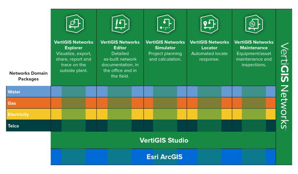
VertiGIS Networks is a configurable, web-based application designed to integrate with the Esri Utility Network. It provides a user-friendly interface that allows utility staff to easily visualize, trace, and query network data without needing deep GIS expertise or access to complex desktop tools.
In simple terms, VertiGIS Networks helps water, electric, gas, and telecom utilities interact with their network data more effectively, enabling tasks such as:
- Tracing the flow of water or electricity through the network
- Identifying affected areas during outages or maintenance
- Viewing connected assets like valves, meters, and pipes
- Running network queries quickly and easily through an intuitive interface
The solution is particularly beneficial for field crews, planners, and customer service teams who require real-time access to network information across devices, including desktops, tablets, and smartphones.
Woolpert and Hunter Water professionals carefully managed the development process to ensure timely and budget-conscious delivery.
The Result
The implementation of VertiGIS Networks at Hunter Water has provided several key benefits:
- Intuitive, User-Friendly Interface: Users can now easily interact with complex utility network data, eliminating the need for specialized technical expertise.
- Increased Work Efficiency: Streamlined workflows and task automation enable Hunter Water staff to complete tasks faster, reducing time spent on manual data queries or network diagnostics.
- Improved Customer Service: With tools for tracing and network analysis, end-users can respond to customer inquiries and service requests more promptly and accurately.
- Easily Extensible: VertiGIS Networks is highly configurable, enabling the application to be easily adapted to meet evolving business needs as they arise.


Conclusion
By implementing VertiGIS Networks, Hunter Water has not only streamlined its GIS workflows but also enhanced its operational efficiency and customer service capabilities. The solution offers a flexible, scalable platform that will support Hunter Water’s future growth and technological evolution.
“The implementation of VertiGIS Networks marks a major step forward in how we access and interact with our utility network data. Delivered in close collaboration with Woolpert, we now have a fit-for-purpose, intuitive and user-friendly system that enables informed decision making across our operations.“
Ruben MacNeil, Group Manager – Field Service Model, Hunter Water