


 All Customer Stories

Overview
SLR is a global leader in environmental and advisory solutions that help clients achieve their sustainability goals. The company delivers advice and support on a wide range of strategic and project-specific issues, including engineering, environmental management, planning, approvals and environmental specialist services. Among its environmental specialist services, SLR’s technical specialists provide guidance on acoustics, noise and vibration for a wide scope of projects ranging from city-scale environments to detailed building or infrastructure elements. It offers unique expertise and practical solutions, from planning to construction, which balance potential environmental issues with the need for development. SLR has several construction clients operating in a challenging and dynamic environment in Australia and New Zealand. Clients need to quickly understand the acoustic impact on nearby properties of construction equipment operated at different times and locations. To better serve these clients, 1Spatial Australia worked with SLR to create an automated, mobile noise assessment service using Safe Software’s FME Server.
Challenge
SLR has several major construction clients – many of them delivering road and rail infrastructure projects in Australia – that need a consulting engineer’s report detailing the acoustic impacts to nearby properties of different equipment operated on site before they can commence work. The dynamic and unpredictable nature of construction, such as weather conditions, affects what activities can be carried out requiring scheduling changes. SLR receives requests to produce detailed noise assessment reports at any time of the day or night. It often receives requests after four o’clock on a Friday from construction managers planning weekend shifts. This could be disruptive to construction managers, schedules and SLR employees since it takes hours to update data in spreadsheet macros, adjust the acoustic model, process the calculations and produce a detailed report. Meanwhile, clients would have to wait to receive confirmation if activities were able to be undertaken.
“We needed an automated system with prepopulated modelled data that was readily accessible and could do the accumulated noise assessments for our clients,” said Peter McGown, Technical Discipline Manager, GIS & Information Systems for SLR APAC. “We wanted to move away from a spreadsheet macro environment that needed considerable human manipulation to produce the reports.”
Solution
Mr McGown knew from his experience using Safe Software’s FME in a previous job, that it would be possible to automate the production of reports of acoustic reports. It would require more work upfront for a particular construction project – creating more detailed and flexible acoustic models over a larger area. But it would enable a much more responsive solution for clients and improve SLR’s work environment.
While SLR has expertise in acoustic engineering, the company’s 11-strong GIS team had limited experience using FME. Working with 1Spatial enabled SLR to build an automated end-to-end solution using FME Server.
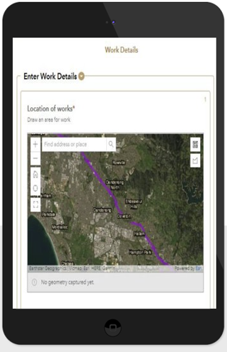
The solution involves many elements. An FME Server workspace containing the acoustic models data summarises the accumulated noise levels at nearby properties based on the type of construction equipment used, their location and time of day. It also produces a detailed PDF report and emails it to the requesting construction manager, community consultation or team if required. In addition, SLR knew that construction managers would mostly be onsite when making requests, without access to a laptop or desktop computer. SLR’s preferred mapping tool is Esri’s ArcGIS, and the company decided to use its mobile app to collect input from the managers. While SLR created the user interface in ArcGIS, 1Spatial configured the workbench for the first construction project in FME Server. These included the calculation elements for different construction equipment from multiple locations, the locations and requirements of nearby properties such as homes, schools, hospitals, and the noise impacts on other sensitive receptors.
1Spatial also configured cloud-based integration in FME Server to the ArcGIS mobile app to accept the client input, trigger the production of a PDF report, and email it to the construction manager.
Comprehensive documentation of the FME workspace was critical to the solution’s success, said Mr McGown. “We didn’t want a black box solution. You want to know what is under the hood. We needed something that we could further customize ourselves in the future.” “One of the benefits of 1Spatial’s solution is that the parameters and inputs can be changed to meet state government requirements and other noise guidelines, as well as being customized for individual projects.” “FME also gives us a powerful tool to provide extra functionality for the entire SLR APAC team of 600 people. It is making our processes quicker and more flexible. With FME, they are not locked in stone.”
– Peter McGown, Technical Discipline Manager, GIS & Information Services, SLR Australia
“The project was a great success in part to the collaboration we had with the SLR team. Working together to design, build, test and launch the optimal solution. We continue to work with SLR in ensuring the success of the application.”
Ashish Manandhar – Senior Consultant – 1Spatial Australia
All Customer Stories