



 All Customer Stories
“The sky is the limit. There are so many more opportunities to streamline and automate tasks with FME, such as reducing our staff’s manual handling tasks in the TechOne system and enhancing field data capture. Automating these manual tasks is incredibly satisfying, but we can do much more. We will build on this work and continue to develop it further.”
Nathan Sharp, GIS Manager, City of Cockburn

Overview
Located around 20km south of Perth city centre, the City of Cockburn is home to 130,000 people, with the community expected to grow to more than 170,000 residents by 2026. Encompassing 23 suburbs, the city has many attractions, including some of the best wetlands in Western Australia, extensive employment opportunities and well-established community facilities.
The City of Cockburn is committed to supporting a high quality of life for its residents. It provides a range of local government services, including support for community and local businesses, environment and waste, health and safety, buildings and roads, and recreation and tourist attractions.
The city’s staff rely on information technology systems, including TechnologyOne ERP and ESRI ArcGIS, to handle requests and manage tasks. The city has streamlined many manual processes enabling, for example, field workers to navigate to request locations, complete tasks and record information on-site.
Challenge
The City of Cockburn’s enterprise resource planning (ERP) system from TechnologyOne, was scheduled for migration to the cloud with a November 2024 go-live date. This presented a challenge to the city which, over 20 years, had developed numerous integrations between the city’s geographic information system, ESRI ArcGIS, and TechnologyOne.
These integrations allowed requests, tasks and associated information in TechnologyOne, to be exchanged with ArcGIS so geographic and additional workflow functionality could streamline and enhance processes for field workers. Developed using SQL stored procedures and Python code to access on-premise databases, however, the integrations would not work when TechnologyOne moved to the cloud.
The GIS team, led by GIS Manager, Nathan Sharp, had identified that the city’s existing systems integration methodology was no longer adequate. The original developers had left the organisation, and their replacements had different skill sets. In addition, because they were coded and not self-documenting, the integrations had become difficult to understand, troubleshoot or modify.
To meet its TechnologyOne cloud migration deadline and ongoing integration requirements, “we wanted a tool for long-term integration models which was visually self-documenting for knowledge transfer,” said Sharp. The GIS team was confident Safe Software’s FME data integration tool could do the job and engaged 1Spatial, the Leading Global Partner of Safe Software and Australasia’s largest and longest serving Value-Added Reseller of FME, to develop a Proof of Concept (PoC) solution.
Solution
The City of Cockburn asked 1Spatial to work collaboratively to develop an integration in FME for its waste solution, its most complex challenge. The city also engaged 1Spatial to upskill the GIS and Business Systems teams with FME training courses tailored to individual requirements.
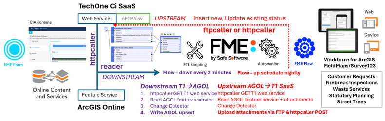
1Spatial Integration Specialist, James Botterill, worked closely with the city’s Lead GIS Developer, Akiyoshi Kawamura, to migrate its integrated waste solution in the cloud. This managed the dispatch, navigation, fieldwork, escalation, reattempt and job closure of customer requests from TechnologyOne in ArcGIS before importing the updated record and new documentation into the ERP.
The City of Cockburn initially determined that secure File Transfer Protocol (sFTP) was the most viable data exchange method. Midway through the PoC development, however, 1Spatial and Cockburn became aware that TechnologyOne offered a RESTful Web Service supporting custom application programming interfaces (APIs).
As FME has transformers for both sFTP and Web Services, the team switched to Web Services to support more robust, granular and responsive data exchange. In conjunction with FME’s Change Detector, which monitors TechnologyOne and ArcGIS for changes to trigger workflows and keep the systems in synch, Botterill and Kawamura configured a solution that exchanged data every two minutes.
Concurrently, 1Spatial delivered FME training to the city’s 4-person GIS and 6-person Business Systems teams. After testing the waste PoC, the GIS team then completed other cloud ERP/GIS integrations for processes supporting community safety and vehicles in the field (CoSafe) and managing street trees, firebreak applications, statutory planning forms, graffiti requests, and various online customer request forms via the city’s website. The PoC took two months, and all the field systems integrations were completed within six months, ensuring a smooth transition to TechnologyOne in the cloud.
The City of Cockburn not only met its cloud migration deadline but, moving forward, can easily maintain and develop streamlined and enhanced end-to-end data flows between any systems it needs to integrate. For example, the Business Systems team also used FME to integrate its on-premise reporting and compliance solutions with TechnologyOne to maintain their continuity, and several other integrations are planned.
“Implementing the entire integration process with Python scripts was not a sustainable option due to maintenance complexity. With FME, you can configure a self-documenting and transparent process so anyone in the team can manage it. We have also used Python scripts to import asset data. With FME, we could automate and publish that process so the Assets team can validate it. There are lots of things we can apply FME to.”
– Akiyoshi Kawamura, Lead GIS Developer, City of Cockburn
“The City of Cockburn wanted to build the capabilities of their people, which made them great to collaborate with. Many organisations are happy to outsource and pay more for a solution. But if they can train their own people, who know the business, to do a fraction of what we can do with FME, they can come up with far better solutions.”
– James Botterill, Integration Specialist, 1Spatial Australia
All Customer Stories