



 All Customer Stories
“FME allows us to work in a very agile way. Application integrations that might take a month or a year in other environments can be deployed with FME in hours or days. That’s incredibly satisfying, especially when I see how it helps our operational teams work more efficiently”
– Anderson Zapata, Solutions Architect, Sunwater
Overview
Sunwater is an Australian bulk water provider that owns and operates a network of storages and water supply schemes across the state of Queensland. It captures, stores and delivers around 40 per cent of Queensland’s commercial water, supporting regional growth and prosperity.
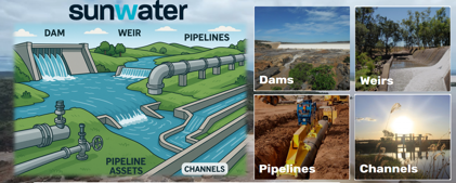
Sunwater operates in a dynamic environment where efficient resource allocation and exceptional customer service are essential. With a focus on delivering reliable water services and maintaining asset integrity, the company relies on accurate and timely data to support operational decisions and activities.
In this environment, optimal resource planning and precise location-based information are crucial.
Sunwater uses SAP for enterprise resource planning (ERP) and asset management, while its GISMO GIS viewer, built on Esri’s ArcGIS, serves as a mapping tool and source of truth. Until recently, these systems operated in silos, with limited integration.
Challenge
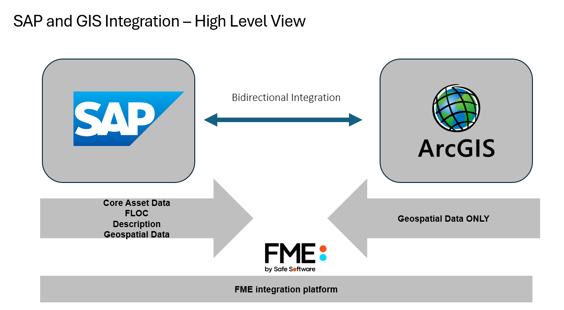
An upgrade to S/4HANA, SAP’s newest generation ERP software, which supports cloud deployment, mobile computing, analytics and AI, has given Sunwater a boost in asset management functionality. In particular, SAP’s new Geographical Enablement Framework (GEF) promised to boost the productivity of operational staff or people in the field. Traditionally, Sunwater’s workforce used individual local knowledge to locate assets in the field without the support of geospatial systems. However, as the company has expanded, supporting technologies have become necessary to assist staff in accurately locating assets in the field. To better support its operational staff or people in the field, Sunwater adopted GEF as part of the SAP upgrade and uploaded geospatial data from CSV files exported from GISMO. Operational staff or people in the field could now view asset locations in S/4HANA on their mobile devices. In remote locations, asset sites may be unfamiliar or overgrown, meaning potentially unsafe field conditions and inefficiencies in finding assets without location assistance. When Sunwater investigated the issue and compared the locations of assets between S/4HANA and GISMO, a considerable variation was found. The difference could be as low as 20 metres or as high as 500-1000 metres. After using GPS devices to verify the accuracy of the data in GISMO, it became apparent that S/4HANA and GISMO used different geospatial coordinate systems, and further data transformation would be required.
Solution
Sunwater decided to acquire more sophisticated integration capabilities and embarked on a technology review, initiating proof-of-concept (POC) projects to assess which approach and tools would best fit its requirements. This involved several testing tools that could integrate S/4HANA with ArcGIS, as well as creating programs using SAP’s Advanced Business Application Programming (ABAP) language.
ICT and GIS teams implemented two POC projects using Safe Software’s FME, an enterprise integration platform with comprehensive spatial data interpretation capabilities. In addition to the S/4HANA POC, Sunwater used FME to integrate ArcGIS with the Salesforce Customer Relationship Management application.
An evaluation of the POC projects found that “FME was the most seamless and cost-effective approach,” said Anderson Zapata, Solutions Architect. “The two projects demonstrated the need to introduce an integration tool into Sunwater’s enterprise environment, and both of them have been running successfully ever since.”
By integrating SAP and ArcGIS, Sunwater enabled mobile apps to display accurate asset locations, link work orders and notifications, and allocate tasks more precisely. FME also introduced robust validation capabilities. Data from different endpoints could be checked for spelling, formatting, timestamp consistency and schema alignment before being accepted into downstream systems. This reduced the risk of errors and ensured that only high-quality data flowed through the enterprise.
“The productivity of operational staff or people in the field has increased enormously,” said Zapata. “They have been saving 1-3 hours per job because the integration is working. They can go straight to the asset, take photos and even see if there’s another valve nearby that needs inspection. That increases their capability to complete multiple tasks more efficiently.”
Sustainability
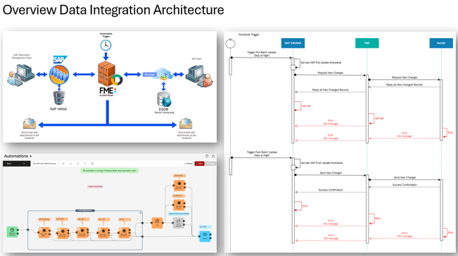
Sunwater’s technology review also exposed broader enterprise application integration requirements. Like most organisations, it had accumulated ad hoc data integration methods over time. These included Excel spreadsheets, Power Automate flows, PowerShell routines and Python scripts. FME offered Sunwater a pathway to sustainable enterprise application integration practices through centralising all enterprise data transformation workflows. With visibility into how data was transformed and exchanged between systems, FME could help troubleshoot issues and ensure data quality. This, in turn, would increase confidence in enterprise systems like S/4HANA, support their successful adoption, and help boost productivity. To deploy FME beyond the geographical information systems area, however, other team members needed training. This would allow Sunwater ICT and GIS teams to refocus on solution architecture rather than building integrations, utilising FME’s no-code interface, which does not require expert skills. Sunwater also needed a responsive backup support service and access to expert FME consultancy for complex integration projects. To enable this broader adoption of FME, Sunwater engaged system support partner 1Spatial, the Leading Global Partner of Safe Software and Australasia’s Largest Value-Added Reseller of FME®, purchasing a managed support service and training.
“We now collaborate with 1Spatial for technical support as a routine business-as-usual process,” said Zapata. “Another part of the engagement is training to upskill the knowledge of the teams and, when required, helping them create FME workbenches and assisting with the deployment of the integration and workflows. With that in place, the use of FME is starting to snowball.”
Sunwater continues to expand its use of FME, including integrations that support AI-driven analytics and predictive maintenance. For example, a new Dam Monitoring System will utilise FME to integrate high-velocity, real-time data collected from onsite telemetric instruments with databases, visualisation tools and other enterprise systems. With support from 1Spatial, Sunwater is building a foundation for continuous improvement – one where data transformations and flows are reliable, transparent and aligned with business goals.
“We’ve demonstrated FME’s performance as an enterprise integration tool. It’s not just used for spatial data. It’s also used for non-spatial data, enabling seamless integration across all our applications. It’s part of the discussion we have every single day.
“It’s all about better data management. Having FME as a low-code integration solution helps us understand how processes run, even if you don’t understand coding. It gives us control and traceability and builds confidence so people can rely on and trust the information.”
– Anderson Zapata, Solutions Architect, Sunwater
“Sunwater has taken control of its enterprise application integration. With 1Spatial backing it up, Sunwater can broaden the self-reliance it has already shown with FME to create sustainable data integration practices that are more flexible and cost-effective than other methods.”
– Christian Fellinger, Sales Director, 1Spatial Australia
All Customer Stories