


 All Customer Stories
.
“VertiGIS Networks puts the ability to trace and isolate the water system directly into the manager’s hands.”
.
Located in southeast Texas, the City of Houston is the fourth-largest city in the United States and home to more than 2.3 million people. Houston Public Works, a department of the City of Houston, supports the city’s growth, mobility, resilience, and quality of life through critical public infrastructure and services. The department serves a broad range of areas, including water, wastewater, transportation, drainage, solid waste, and other essential public services. The scale and complexity of these services create an enormous and continually evolving need for accurate, accessible, and reliable geographic information to support operations, planning, and decision-making.
For Houston Public Works, GIS modernization started with a simple reality: a system that had served the organization well for decades was being asked to serve a very different world.
As GIS adoption expanded across business units, field teams moved from paper to digital tools, and cloud infrastructure became more complex, Houston needed an approach that could scale with both its technology and its people.
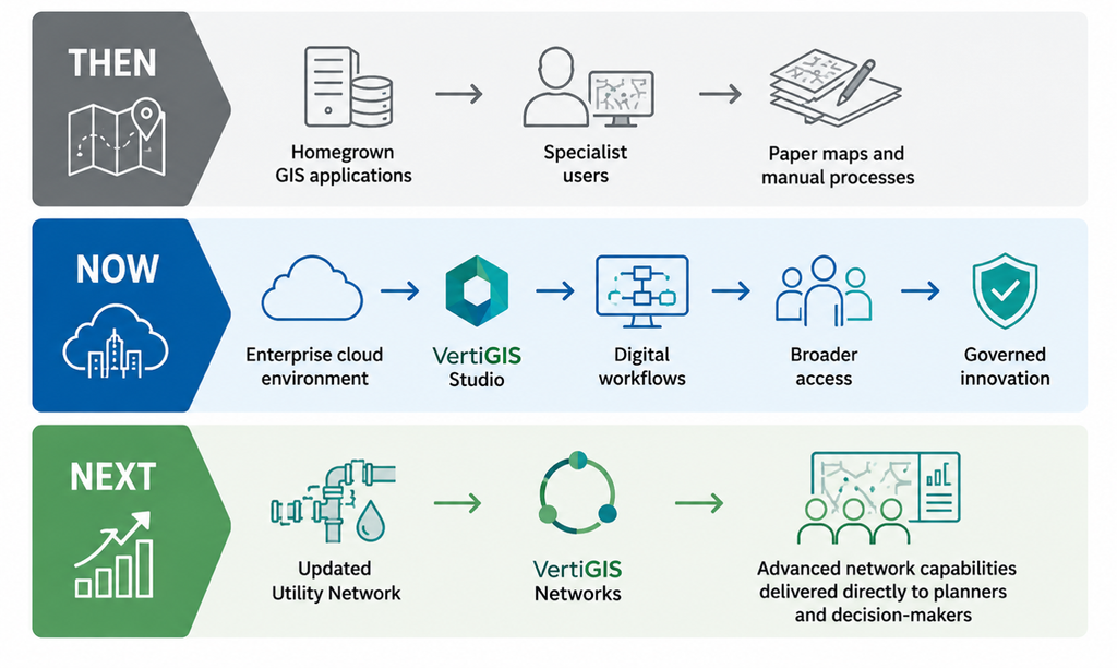
Today, Houston Public Works is building an enterprise GIS environment around standardized applications, improved workflows, and stronger governance, with VertiGIS Studio helping make sophisticated GIS capabilities more accessible across the organization.
Along the way, the team has learned an important lesson: modernization digitizes how you work, but it’s also an opportunity to make the work better.
The Challenge: When GIS outgrows the GIS department
Houston’s modernization journey began roughly eight years ago, but its roots stretch back much further. For decades, Houston Public Works relied on an internally developed system to give employees and the public access to GIS assets. It was reliable and effective, but the environment around it was changing.
Houston transitioned toward a configurable, off-the-shelf approach with Geocortex while also beginning its move to Amazon Web Services (AWS). At first, the relatively small GIS team could add infrastructure as needed. But as GIS adoption expanded across Public Works business units, so did the demands on the environment.
More people needed accounts, different access levels, web applications, and eventually mobile solutions. Inspectors who had once picked up printed map books and headed into the field increasingly needed digital information and applications instead.
Houston had reached the point where simply adding capacity wasn’t enough. It needed an enterprise architecture.
The Solution: Building an enterprise foundation
City of Houston stepped back and brought together technical expertise from AWS, Esri, and other vendors to design an optimized cloud infrastructure to support its growing GIS community. Building that new environment took about a year, and Houston is now transitioning its data and applications into it.
VertiGIS Studio is part of that transition.
The configurable, low-code/no-code approach continues a model Houston had already embraced with Geocortex, while Studio Forms, reporting, and workflow capabilities are helping the organization go beyond simply putting existing tasks online.
One example is Houston’s sidewalk program. Previously, a citizen requesting a new sidewalk might email a council member. That request would be forwarded to the appropriate business unit, often followed by emails or phone calls to establish details such as the exact location, side of the street, and length of sidewalk being requested.
Using VertiGIS Studio Forms, citizens can instead start from a single location, answer structured questions, and use a map to sketch where the sidewalk is needed and its approximate extent. The request is then routed to the appropriate team with more complete information already attached.
Staff can begin evaluating the request with a clearer understanding of what’s being asked, and citizens can provide much of the necessary information themselves.
Don’t just automate the old process
The sidewalk example reflects a larger change in how Houston approaches modernization. After seeing one of the organization’s early mobile solutions, the project team was challenged: “You took what was on paper, and you automated it, but did you improve the process?” The question stuck.
Instead of simply asking business groups how they perform a task today and reproducing those steps digitally, Houston began looking for opportunities to improve the underlying process. The direction became: Don’t just automate past processes. That mindset has become part of Houston’s broader enterprise GIS transformation.
Governance without shutting down innovation
Modernization has also required Houston to address something less visible than applications and infrastructure: culture and governance.
As GIS capabilities expanded within individual business units, duplication grew as well. Different groups could perform similar activities and sometimes produce different results. Application development also became increasingly decentralized, creating challenges around consistency, performance, and security.
The City of Houston is now formalizing an enterprise governance model designed to balance business-unit expertise with consistent IT oversight.
Business-unit GIS specialists will remain the experts responsible for creating and maintaining core operational data. They’ll also have access to a development and test environment where they can experiment, perform analyses, and prototype ideas for their managers.
If an idea proves valuable enough to become an operational application, it can then move through a formal request process into the production environment, where IT can address hosting, security, performance, and external access.
The objective isn’t to stop innovation. It’s to create a safer, more consistent path from experimentation to production.
The Utility expects to establish the first phase of its new governance framework in late 2026 and emphasizes that governance itself will continue evolving. “Governance is one of those things that never stops.”
Four lessons from Houston’s GIS modernization
Houston’s journey offers several useful lessons for other organizations thinking of similar transformations:
- Don’t confuse digitization with improvement. Before automating an existing workflow, ask whether the process itself should change.
- Design for where GIS adoption is going. Infrastructure that works for a small specialist team may not work when GIS becomes an enterprise capability.
- Give innovation some guardrails. A sandbox gives business teams freedom to experiment, while a governed production process protects security, performance, and consistency.
- Bring GIS intelligence closer to the decision. The value of sophisticated GIS capabilities grows when planners, managers, and other operational users can access them without becoming GIS specialists.
What’s next: Extending Utility Network intelligence
Houston’s next chapter is already underway. Approximately four years ago, Houston transitioned its water, wastewater, and storm utilities from Esri’s Geometric Network to Utility Network. The city is now upgrading that environment to establish VertiGIS Networks alongside it.
One planned use case is giving water planners and managers easier access to isolation and tracing capabilities. In Houston’s largely flat, pressurized water system, that could help users investigate leaks and other issues and understand their potential impact without relying exclusively on specialist desktop users.
That’s an important evolution: putting sophisticated network capabilities “into the manager’s hand.” Houston is targeting completion of the Utility Network upgrade and establishment of VertiGIS Networks around the end of its 2026–27 fiscal year, while its migration from Geocortex applications to VertiGIS Studio is already progressing.
City of Houston’s GIS Journey
Making a powerful toolbox easier to use
For other agencies considering a similar path, the utility sees value in configurable solutions like VertiGIS Networks for organizations that may not have the resources to maintain large teams of experienced developers. Esri provides organizations with an enormously capable toolbox and the freedom to build what it wants. VertiGIS helps position those tools so users can more readily select what they need and assemble a solution.
The City of Houston’s experience suggests the real opportunity goes beyond choosing better tools. Building an environment in which technology, workflows, governance, and people can evolve together.
All Customer Stories