



 All Customer Stories
The Road Information System (SIB) Bavaria is the core component of the Bavarian Road Information System (BAYSIS). This system manages and provides essential data on Bavaria’s road network and serves as the foundation for numerous applications within the Bavarian State Construction Administration.
The Challenge
With growing demands and increasing data volumes, a complete modernization of the system became essential. The new development aimed not only to deliver enhanced functionality but also to enable more dynamic and efficient management and visualization of road data. The goal was to create a centralized, future-proof system that optimizes data usage and ensures seamless integration with third-party systems.
The Solution
To realize this ambitious project, Atos acted as the general contractor, while VertiGIS served as the technology partner. Together with a bidding consortium — including con terra, interactive instruments, and Esri Germany — they successfully competed in a comprehensive tender process run by the Bavarian State Building Authority.
VertiGIS took the lead in agile development, contributing its extensive expertise in modern GIS technologies to create innovative solutions tailored to the project’s specific needs. This clear division of responsibilities allowed each partner to leverage their strengths and contribute effectively to the project’s success.
The new SIB Bavaria was developed using Esri’s ArcGIS Roads and Highways. Leveraging modern technologies such as ArcGIS Pro Add-ins, server components, VertiGIS Studio, and VertiGIS Inline, the team delivered a powerful solution that fully meets current demands. The project followed an agile approach using Scrum to remain flexible and to align closely with the client’s needs while building a future-ready platform.
The new system enables dynamic and user-friendly editing and visualization of roadside objects. Cross-section and structural layer visualizations and analyses are also possible in real time. Furthermore, the system allows seamless integration and use of data by third-party systems.
The agile project management focused on three core areas:
1. Data Migration – Transferring existing data into the new system laid the foundation for modern road management.
2. Interface Implementation – Enabling smooth integration with external applications and specialized processes.
3. Maintenance and Ongoing Development – The system was designed to be continuously improved and adapted to meet future needs.
Through the combination of ArcGIS Pro add-ins, server components, and VertiGIS’ innovative tools, a cutting-edge system was created—optimized for long-term use.
The Result VertiGIS played a key role in the successful implementation of the project led by Atos. The result is a centralized, high-performance platform forming the backbone of the Bavarian Road Information System (BAYSIS).
Project highlights:
· Centralized Data Base: Comprehensive road network and asset data enable efficient usage across various technical applications.
· Third-Party Integration: Real-time online data access significantly improves planning and road network management accuracy.
· Future-Ready Platform: The new SIB Bavaria is flexible and scalable—serving as a model for similar projects in other federal states.
With this solution, VertiGIS not only met rising demands but also laid a solid foundation for the future use and advancement of modern GIS technologies in road infrastructure management. This project clearly demonstrates how VertiGIS applies innovative GIS solutions to solve complex challenges and deliver long-term value to clients.
The SIB Bavaria team is equally enthusiastic:
“The collaboration between VertiGIS and Atos allowed us to develop SIB Bavaria at a very high technical level. The solution not only offers a centralized platform for capturing and analyzing our road data, but also sets entirely new standards for IT systems in road construction within the Bavarian State Construction Administration,” says Christian Stemp, (BAYSIS-IT Representative and Product Owner for the project) at the Bavarian State Building Authority.
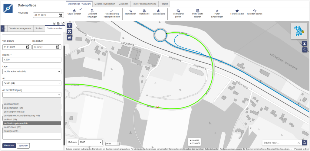
Image: With the VertiGIS Studio Data Management App, road events can be easily created. (Source: VertiGIS)
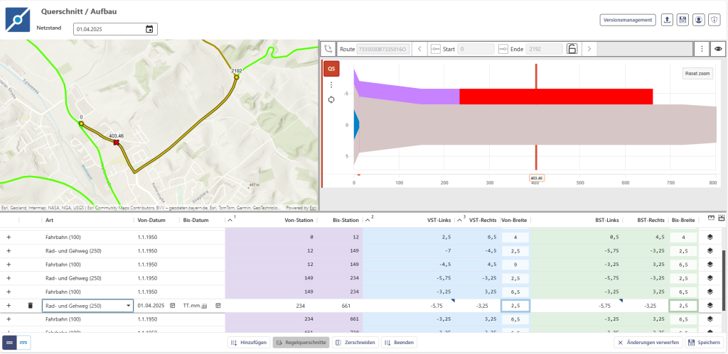
Image: Cross-sections can be analyzed and edited using the VertiGIS Studio Cross-Section & Structure App. (Source: VertiGIS)
All Customer Stories