


The Innovative, Web-Based Solution for ArcGIS®
VertiGIS Networks Solutions for Water Utilities
Modernize Your Network Asset Data Management

VertiGIS Networks merges professional GIS expertise with user-friendly, browser-based solutions to help businesses overcome the challenges of managing their network with ease, efficiency, and precision.
What makes VertiGIS Networks stand out?
Our web-based solutions are designed with functionality and flexibility in mind. Perform lightning-quick network traces using pre-defined trace configurations and automate customer notices for maintenance outages or other disruptions to your water network. Deploy using SaaS and on-premises options, allowing you to choose what best fits your business needs.

Easy Integration
Our suite of products offers an efficient solution for visualizing, exploring, tracing, and editing your water network, all from the convenience of your web browser. Our system integrates seamlessly with your asset management system to automatically trigger work orders and service requests.

Reporting Templates
Generate detailed PDF reports from configurable templates and automate customer service notifications such as boil water advisories or scheduled valve closures. Our powerful search and query features allow you to easily find the exact assets you’re looking for within your ArcGIS Utility Network data.

Work From Anywhere
Our powerful search and query features allow you to quickly locate specific assets within your network, while our intuitive Web and Mobile interfaces give you the freedom to work from anywhere. SaaS and on-premises options allow you to choose what best fits your business needs.
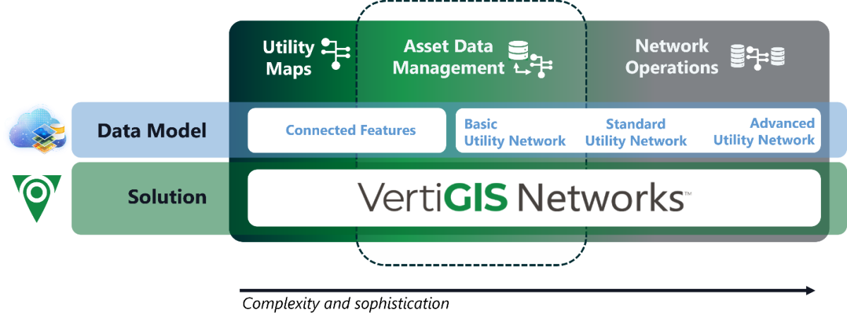
Modernize your network management without starting over.
Now you have the option to choose an easier path to next-generation network management. VertiGIS Networks gives you modern apps that speed up your business processes whether you’re planning a large data migration to Esri’s Utility Network (UN) or need to protect the investment in your current GIS infrastructure.
Simplify and optimize your network asset data management with VertiGIS Networks – a comprehensive software suite for water utilities. If you’re using UN, VertiGIS Networks offers best-in class web editing interfaces for managing your network. If you’re considering a UN data migration, VertiGIS Networks offers applications that provide immediate value without requiring a data model upgrade upfront.
Choose the path that fits your needs, timeline, and budget.
In today’s market, you get a broad variety of Utility Network migration offers. But what do you truly need? We’re here to help you manage the future of your network management without running into the risk of compromising existing integrations with third party systems. Gain immediate value from web-based tools designed to let you do your job more efficiently.
✅ Utilities not migrating to UN (or undecided)
You might not have to migrate to UN to get more value out of your GIS. Put the data to use that you have right now.
✅ Utilities planning a future migration
VertiGIS Networks can be implemented today so your teams can see immediate efficiency. Add functionalities as your data becomes more complex.
✅ Utilities already on UN
You need a powerhouse of functionalities to make the most of your investment? VertiGIS Networks is the most performant suite of tools for you and puts that data into action.
Watch our On-Demand Webinar, hosted by Esri & VertiGIS
Esri’s ArcGIS Utility Network is the state-of-the-art foundation for managing your water utility network, but what about the apps and use cases that put that foundation to work?
In this session, we explore how ArcGIS Utility Network and VertiGIS Networks help water utilities manage common use cases and future-proof their operations. Learn about the benefits of Esri’s ArcGIS Utility Network and the advantages of a web-first approach, so you can edit your networks on the web and generate work orders from anywhere (e.g. through Cityworks integration). This also helps you deal with technology changes on the horizon such as the retirement of Web AppBuilder.

Fill out the form below to access our on-demand webinar.

Contact Us
Utility providers around the world are using Esri’s ArcGIS to manage their network data. Are you ready to get more out of your network data? Contact us now for a free demo.
Contact us
Want to learn more about streamlining operations with cutting-edge water network management?
Download our free Whitepaper.